
Transportation Safety Action Plan
Project Overview
The City of Pleasanton is working to develop a Transportation Safety Action Plan in accordance with the requirements of the U.S. Department of Transportation Safe Streets for All Program.
The purpose of the Transportation Safety Action Plan (TSAP) is to improve roadway safety by significantly reducing or eliminating fatalities or serious injuries to all roadway users, including pedestrians, bicyclists, public transportation users, motorists, personal conveyance and micro-mobility users, and commercial operators.
The Transportation Safety Action Plan (TSAP) will identify data-driven projects and strategies and incorporate best practices, stakeholder input, and equity and environmental considerations to address the needs of the City roadways.
Project Updates
Spring Meetings:
- March 31, 2026 and April 2, 2026 at 6:00 p.m. (Residents have two opportunities to attend.) Community Meeting Info (View Flyer)
JOIN THE MEETING: Zoom Link
Meeting ID: 837 5370 4914 | Passcode: 718597
Past Meetings: September 30, 2025, November 5, 2025, November 6, 2025, and March 24, 2026.
Public Outreach

Public Outreach is an integral part in developing TSAP because it aims to improve road safety and reduce traffic fatalities . Gathering feedback from the community can help ensure the plan addresses their concerns and needs.
The City of Pleasanton will incorporate citizen feedback as part a data-driven effort to eliminate traffic fatalities and serious injuries.
The project survey and Maptionnaire were closed on January 31, 2026. Thank you to all who submitted your concerns.
Please subscribe below to be informed about upcoming community meetings and a future opportunity to participate in a survey.
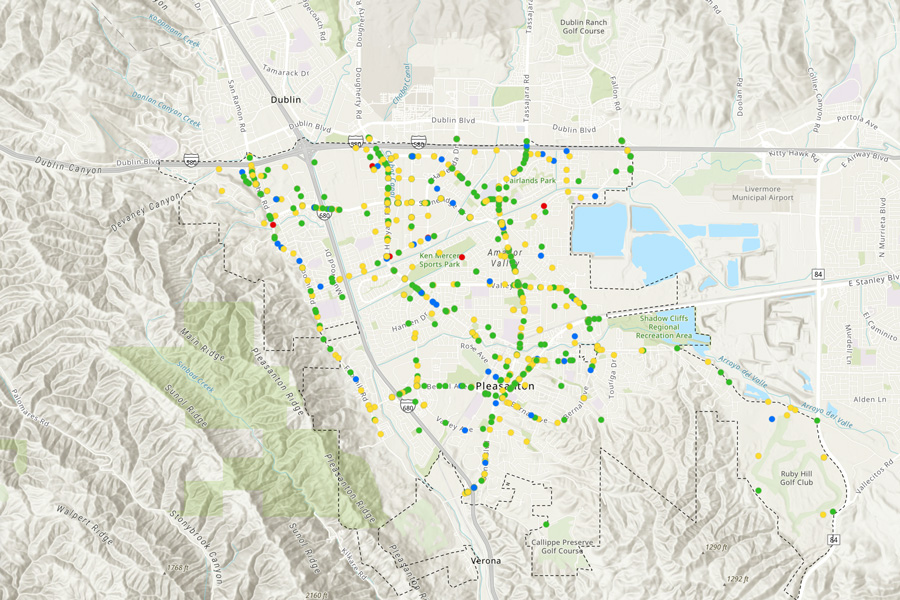
Collision History
The map below shows collisions that occurred within the City of Pleasanton’s city limits from January 2020 to December 2024.
Directions to navigate the collision map:
- Navigate the map to find collision hot spots.
- Use mouse wheel or provided buttons to zoom in and out. Pan by left-clicking on the map or using your device’s touch screen.
- Toggle between base maps by clicking on the map icon on the right side of the window.
- Collisions are color-coded to correspond to collision severity. Use the interactive legend to view collisions of each severity. Click on each collision for more details.
For any comments or suggestions, please Provide Feedback.

Subscribe for Updates
Administration
Transportation Safety Action Plan
Traffic Engineering Division
200 Old Bernal Avenue
Pleasanton, CA 94566
Cedric Novenario
Senior Transportation Engineer
Contact us by filling out the form below: